A historic relief model is at the 118th US Open today. It’s the 1911 relief model of the National Golf Links at Shinnecock Hills, Long Island by Edwin E. Howell.
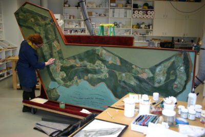
Christine Puza of the Williamstown Art Conservation Center works on the Edwin E. Howell “National Golf Links” relief model. Photo courtesy Christine Puza.
The Golf Links model was restored in 2014 by Christine Puza, Assistant Conservator of Furniture and Wood Objects for the Williamstown Art Conservation Center. I discovered her online article describing the model’s restoration process, and we had an email exchange about the relief model’s history at Shinnecock Hills. The course was undergoing a major restoration of its historic facility first built in 1891.
- What follows is the backstory that updates and expands on Puza’s 2014 article “Links to the Past” in Art Conservator.
What’s a relief model?
A relief model is a 3D map. Edwin E. Howell (1845-1911) was a geologist who crafted relief models in his Washington, DC shop for schools and museums. He created the first commercial relief models in the US and supplied exhibits to the Smithsonian, US Geological Survey, major museums, universities, teacher and military colleges. (A biography of Howell is forthcoming by me in 2019.) His many private commissions included models for Thomas Edison, Prudential Insurance Co., the Panama Canal Isthmian Commission, Standard Oil, major railroads, mines and more.
The commission
The National Golf Links model was a private commission. A Mr. C. B. McDonald first visited Howell in Washington DC on December 20-22, 1909 to discuss and commission the model. The architects at McKim, Mead & White who designed the Clubhouse were familiar with Howell’s work, especially the model for the Pennsylvania Railroad (the architects were designing a new Pennsylvania train station). The commissioned model was delivered to the client in early 1911.
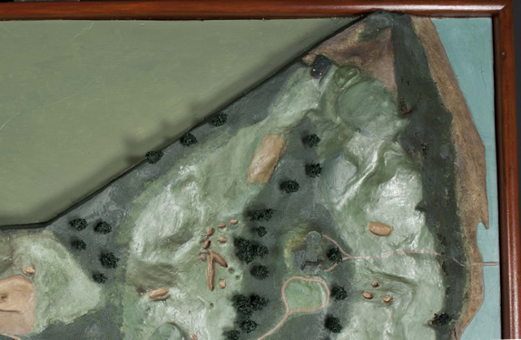
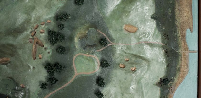
Detail of the National Golf Link at Shinnecock Hills (restored) relief model (1911) by Edwin E. Howell. Note the tiny wire trees, paths, beaches, and roughs on the links. Photo courtesy Christine Puza.
Why a relief model of a golf course?
Before airplanes and aerial photography, relief models could help golfers in 1910 to visualize the unique topography of the whole links. Relief models offered players and course managers an aerial view since the holes had recently been expanded and changed. People could move around the model to get different views, touch the model to understand the terrain, and consider play strategy.
An intimate connection between natural and human-made features defines the geography of golf links. The geology underfoot defines the vegetation and terrain. Young geographers now use GPS, drones, and LiDAR to design and maintain courses.
(For a current view of the course map, see http://www.usopen.com/course.html )
Work and revisions
In April 1910, Howell received flat course maps provided by the links manager. He further consulted topographic maps from the New York Geological Survey and the US Geological Survey. Howell always insisted that his model not only be beautiful visually but also correct scientifically.
For more details on how relief models were built, see my blog post https://melanie.mccalmont.org/making-relief-models/
Then there’s a gap in work performed on the one-of-a-kind model until July 1910. Howell’s shop was busy, simultaneously creating Golf Links and large-scale wet models of Gatum Dam, West Point tanks, and the Baltimore Sewerage Plant. But Howell’s diary shows that over the summer he made two personal visit to the Golf Links to survey the terrain and discuss things with Mr McDonald and the managers. Maps were revised. The vertical scale of the terrain was also adjusted so that it would appear realistic visually.
The National Golf Links model was critiqued by the course managers and Mr McDonald in early 1911. It was finally approved and installed inside the Clubhouse, and photographed. There it was displayed for decades. It was revised and overpainted several times after 1911 with course changes. The oversize, odd-shaped model was also removed from display and stowed away several times–but luckily not destroyed.
The Howell model is now installed in the Clubhouse. The overpaint was removed by the restoration artist in 2014, revealing the original paint and repairing some major damage (see restoration article). The relief model documents one of many national historic sites in Southampton and even natural features, such as Long Island shoreline, that have changed in the last 100 years.
More on the geography of golf courses
Those who play golf will understand why Howell made such a detailed relief model of the links in 1911. Geography and terrain are your friend and enemy simultaneously, and a worthy opponent to study in 3D. Terrain models were originally developed for military purposes, especially in France after 1650, for strategy purposes.
While Howell’s model documents a historic snapshot of human objects on the course, interactive maps and special rules on fixed and temporary immovable objects are still incorporated in interactive online maps of golf courses.
Video of the historic Clubhouse
Should you ever get to Long Island, please make a geographic trek to visit the Edwin E. Howell relief model at Shinnecock Hills!