How does a line of research get started? From January 21, 1877, the Memphis “Daily Appeal” newspaper published a summary of this article in the “Review of Geographic Progress” for 1876.
At the annual meeting of the New York Geographic society, held in Chickering Hall, New York, on Tuesday last, Judge Daly, the president, read a carefully compiled and very accurate review of geographical progress and research for 1876.
The corps of the United States signal service, continued [Judge Daly], have also been making rapid advances during the year toward a complete knowledge of the conditions and causes of the American climate. They have nearly completed the most extensive collection of altitudes of places in North America which has ever been gathered, including several thousand profiles, representing almost every railroad and canal. From this and other data they are making a relief model of North America on a large scale.
A telegraph line has been built by them from Central Texas across the Llano Estacado, that dreaded waterless desert, and one across the high and arid plateaus and ranges of Southern New Mexico and Arizona to San Diego, on the Pacific. This gives an unbroken line from Savannah along the southern border of the United States, stretching from ocean to ocean. Thirty meteorological stations are placed along the line, the highest being [6800] feet above the sea. Another line of stations follows the Rio Grande River from its mouth to the elevated plateau of Colorado. The Mexican telegraph lines now extend from the mouth of the Rio Grande River to San Luis, thence to Tampico, and thence through Vera Cruz along the coast nearly to the extremity of Yucatan.
The signal service are preparing to place stations down even to Yucatan. The gulf of Mexico has been nearly encircled with a telegraph line, along which meteorological stations will be placed at such short intervals that no hurricane or storm can move from the gulf without notice of it escape and the direction of its flight being given at once to the whole country. Arrangements have been made for a chain of stations to the extreme eastern end of the West Indies, all connected by telegraph with the Washington office. If congress is wise enough to give sufficient appropriation to carry out these excellent plans, it will be impossible for any hurricane to enter the United States from the south unheralded, for hourly bulletins of its progress can be posted in every seaport. Who can estimate the lives and treasure that such an arrangement may save?
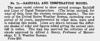
So when I’m searching for references to Howell relief models, I find items like this. It doesn’t mention Ward & Howell, under which name the model would have been crafted, or Edwin alone. But I do know that Edwin Howell made a rainfall model very early (model # 2c) for the young Weather Bureau of the U.S. Signal Corps. Howell made model #2, a curved view 5 1/2 feet in diameter with an overall size of about 1.5 x 2 feet, in 1877. He made an ice sheet version, a geological version, and a temperature & rainfall version. So it’s likely that the Weather Bureau director, Gen. Albert J. Myer, inquired through his military channels and topographers such as Hayden and Wheeler who knew Howell, and that he was doing relief models and maps.
This is the pleasure of research for me. The wealth of online newspapers from the period, databases of photographs and pamphlets, make doing this connecting research a weeks-long effort instead of–well… maybe no effort since the newspapers would not exist or have to run down in every local library.
None of this–none–would be possible without the steady diligence of librarians!

